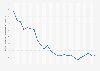
This graph shows the GDP of the Detroit metro area from 2001 to 2020. In 2020, Detroit’s GDP amounted to 220.77 billion U.S. dollars.
Gross domestic product of the Detroit metro area
The Bureau of Economic analysis reported Detroit’s GDP from 2001 to 2020. Over that 19 year span, GDP rose from 220.10 billion U.S. dollars in 2001 to 220.77 billion U.S. dollars in 2020, dipping in 2009 to 187.25 billion U.S. dollars. Despite a rise in GDP, the city of Detroit filed for bankruptcy in July 2013 with debts of approximately 18 billion U.S. dollars. Detroit was the largest municipality to file for bankruptcy since 1953. Second largest was Jefferson County, Alabama, which filed in 2011 with debts of approximately 4.2 billion U.S. dollars.
Detroit was once a major production hub of the American automobile industry, but has since suffered decline as car manufacturers faced international competition and automobile production was moved out of the city. As a result, workers left Detroit and the population fell from a peak of 1,850,000 in 1950. As of 2019, Detroit had a resident population of roughly 670,030 people, ranking 24th on the list of largest U.S. cities. Poverty remains a problem for the city and many buildings remain empty and derelict. Crime rates also indicate the extent of Detroit’s decline. Detroit was the second most dangerous city in America in 2020, with 2,178.54 crimes per 100,000 residents.
GDP of the Detroit metro area from 2001 to 2020
(in billion chained 2012 U.S. dollars)
The Detroit metropolitan area, often referred to as Metro Detroit, is the metropolitan area located in Southeast Michigan centered on the city of Detroit which shares an international border with Windsor, Ontario. The United States Office of Management and Budget defines the Detroit–Warren–Livonia Metropolitan Statistical Area (MSA) as the six counties of Lapeer, Livingston, Macomb, Oakland, St. Clair, and Wayne. As of the 2000 census, the MSA had a population of 4,441,551. The Census Bureau's 2009 estimate placed the population at 4,403,437, which ranks it as the eleventh-largest MSA.The MSA covers an area of 3,913 square miles (10,130 km2).
Profit from the additional features of your individual account
Currently, you are using a shared account. To use individual functions (e.g., mark statistics as favourites, set
statistic alerts) please log in with your personal account.
If you are an admin, please authenticate by logging in again.
Statista Accounts:
Access All Statistics. Starting from $468 / Year
Learn more about how Statista can support your business.
BEA. (December 8, 2021). GDP of the Detroit metro area from 2001 to 2020 (in billion chained 2012 U.S. dollars) [Graph]. In Statista. Retrieved August 09, 2022, from https://www.statista.com/statistics/183873/gdp-of-the-detroit-metro-area/
BEA. "GDP of the Detroit metro area from 2001 to 2020 (in billion chained 2012 U.S. dollars)." Chart. December 8, 2021. Statista. Accessed August 09, 2022. https://www.statista.com/statistics/183873/gdp-of-the-detroit-metro-area/
BEA. (2021). GDP of the Detroit metro area from 2001 to 2020 (in billion chained 2012 U.S. dollars). Statista. Statista Inc.. Accessed: August 09, 2022. https://www.statista.com/statistics/183873/gdp-of-the-detroit-metro-area/
BEA. "Gdp of The Detroit Metro Area from 2001 to 2020 (in Billion Chained 2012 U.S. Dollars)." Statista, Statista Inc., 8 Dec 2021, https://www.statista.com/statistics/183873/gdp-of-the-detroit-metro-area/
BEA, GDP of the Detroit metro area from 2001 to 2020 (in billion chained 2012 U.S. dollars) Statista, https://www.statista.com/statistics/183873/gdp-of-the-detroit-metro-area/ (last visited August 09, 2022)