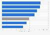
Administrative area of Gyeonggi, South Korea 2022, by district
In 2022, out of the districts of South Korea's Gyeonggi province, Yangpyeong-gun had the greatest administrative area with around 878 square kilometers. Gyeonggi province lies in the country's northwest and surrounds its capital city, Seoul.